
Aquifers Definition
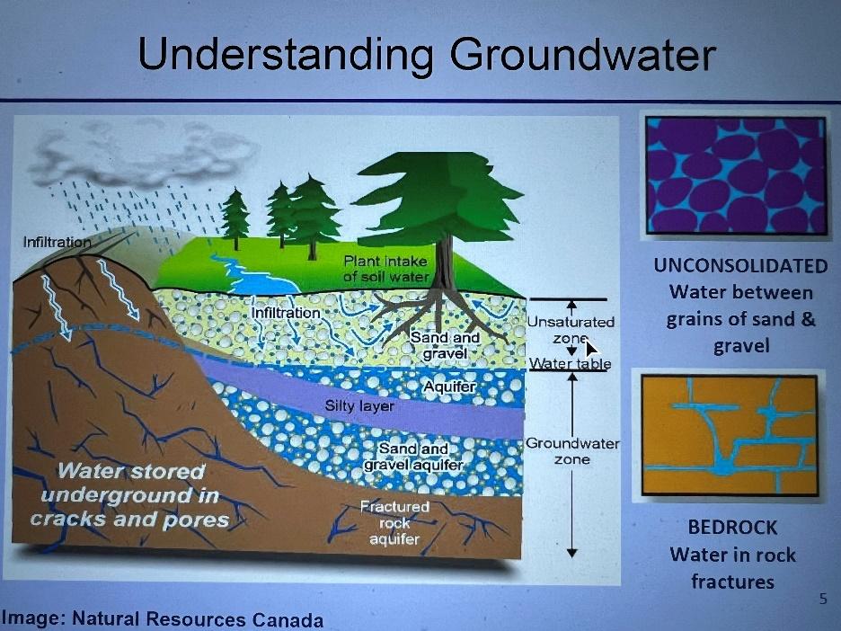
The Britannica (1) defines an aquifer as “a rock layer that contains water and releases it in appreciable amounts.” Although adequate in a general sense, the definition fails to portray the range of geological settings and types of aquifers. The figure below is a conceptual model from a presentation to the Capital Regional District (CRD) by staff of the Ministry of Forestry, Lands, Natural Resource Operation and Rural Development (FLNR) (2) that displays the geology and groundwater hydrology of the CRD.
Figure 1 Conceptual model of the groundwater system of the Capital Regional District, BC (1)
Geology.
The local geology consists of two major rock types: crystalline volcanic rocks (basalt, brown in Figure 1) and clastic sedimentary rocks (sand and gravel, pebbly yellow, blue and purple in Figure 1). The basaltic rocks are dark green, brittle, and fractured rocks making up Broom Hill and the hills exposed in road cuts along highway 14, east of Saseenos. The sedimentary rocks are softer, granular rocks that make up the valley bottoms and lowlands and are composed of sand, silts, clay and gravels left behind by retreating glaciers and streams that flowed over earlier deposits. The sedimentary rocks are exposed in the wave cut beaches along the coast.
Where you live, in the uplands or the lowlands, may determine the type of aquifer your well taps. Figure 1 shows two important types of aquifers: Unconsolidated and Bedrock.
Unconsolidated Aquifers
Unconsolidated aquifers form when water seeps through the surface soils and rock into the subsurface composed of gravel, sand, silt, and clay. The openings (voids) between the grains form granular porosity. The porosity of unconsolidated aquifers varies depending upon the relative proportions of fine grained and coarser grained sediments. Zones composed of large amounts of coarse-grained particles such as gravel, sand, and silt (termed well sorted sediments) – for example buried stream channels, often have higher porosity and may trap relatively large volumes of water. These types of aquifers often meet the criteria of both storing and releasing groundwater. Zones with a lot of fine grain sizes including clay and silt (termed poorly sorted sediments), often have low porosity, store lower volumes of water and slow the flow of water through the ground.
Bedrock Aquifers
Bedrock aquifers form when water seeps through surface fractures into crystalline rocks such as basalt. Basalts are composed of interlocking crystals formed by cooling of lava and, although they have no porosity, basalt is brittle and often fractured leading to fracture porosity. The size of bedrock aquifers depends upon the size and frequency or interconnectivity of the fractures. Because bedrock aquifers are limited to discrete fracture systems or fracture “sets”, drilling wells to intersect one or more fracture sets can be difficult. Bedrock aquifers often drain and refill quickly depending upon the size of the aquifer and the depth where the well intersects the fracture sets.
Water Table
Figure 1 includes a blue line marking the water table. The water table is the boundary between soil and rock partially filled with water (the unsaturated zone), and soil and rock completely filled with water (the saturated or groundwater zone). The water table elevation fluctuates seasonally between wet seasons with heavy precipitation and high rates of recharge, and arid seasons with reduced rainfall and reduced recharge. Other stressors on water tables can include groundwater extraction through pumping or excavation.
Recharge
Recharge is the mechanism by which both unconsolidated and bedrock aquifers refill the ground water. The water table generally parallels the surface of the ground, rising to higher elevations beneath mountains and hills, and to lower elevations in valley bottoms. Shallow recharge occurs by infiltration through the soil immediately above the water table. Figure 1 includes narrow arrows marking the path of ground water flow. However, groundwater flow from higher elevations recharges the deeper aquifer. The heavy white arrows in Figure 1 mark the path of infiltration in the mountains. Surface water flowing deeper underground along the fractures refills the deeper bedrock aquifer.
Confined aquifer and unconfined aquifers
A final feature of Figure 1 is the distinction between confined and unconfined aquifers. Figure 1 includes a thin purple seam, labeled silt. Just like coarse gravels can hold and transmit groundwater, seams of rock composed of fine-grained material such as clays and silt can slow and stop the stop the flow of ground water. Impermeable rocks such as the silt seam are called aquitards, meaning they retard the flow of water. The aquifers above the silt seam are called unconfined aquifers because the aquifer communicates directly with the surface. Rain can seep throughout the soil and sand and gravel into the unconfined aquifer.
The confined aquifer lies beneath the silt seam. As a consequence, recharge to the lower sand and gravel aquifer depends entirely upon lateral flow of groundwater, from the fractured rock aquifer exposed in the mountains.
Aquifers of the CRD
The basaltic bedrock and overlying glacial and sedimentary units that underlie the town of Sooke and the CRD constitute the groundwater aquifers that supply water to the outlying residents on wells. Table 1 lists the individual aquifers and the geologic units that host the aquifers. The different geologic units range in age from the basaltic rocks of the Metchosin formation which are 50 to 56 million years old, to the younger, post-glacial units such as Quadra Formation (26,000 years old), Vashon till (17,000 years old), and the Capilano formation (14,000 years old).
Table 1 CRD Aquifers in the Sooke Area (3)
| Names | |||
| Aquifer number | Aquifer name | Inferred geologic unit | Rock type |
| 599 | Sooke River | Capilano Formation | sand and gravel, clay and silt |
| none | Vashon till | sandy, gravely clay | |
| 604 | Young Lake | Quadra Formation | sand, sand and gravel |
| 449 | Muir Creek | Sooke Formation | sandstone, siltstone conglomerate |
| 606 | Sooke Metchosin | Metchosin Igneous Complex | volcanic rock, basalt |
| Aquifer properties | |||
| Aquifer number | Aquifer name | Type | Confined / unconfined |
| 599 | Sooke River | Aquifers or aquitards | partially confined |
| none | Aquitard | ||
| 604 | Young Lake | Aquifer | confined |
| 449 | Muir Creek | Aquifer | partially confined |
| 606 | Sooke Metchosin | Aquifer | partially confined |
Figure 2 is a map showing the distribution of aquifers in the Sooke area. Included in the map are the 449, 599, 604, 604, 606 aquifers. Aquifer 604 is not included in the discussion that follows because it is less than 1 km2 and considered insignificant. Figure 2 shows that, with the exception of aquifer 604, the other local aquifers are only partially confined. Although the absence of a cover may improve the likelihood of surface recharge, the absence of an overlying aquifer or a low permeability overburden may also leave the unconfined or partially confined aquifer vulnerable to contamination. The red “X” pattern in figure indicates high vulnerability to contamination. Only aquifer 604 is shown in green, indicating a low vulnerability to contamination.
Figure 2 is a map showing the locations of the aquifers listed in Table 1 (3)


Figures 3 is small portion of a larger east-west cross section though the lowlands near Sooke. The hill on the right is the western slope of Broom Hill, and the valley shown is Cooper Cove. The cross section is shown in Figure 2. The figure includes from bottom to top: aquifers 606 and 604 which are confined aquifers and aquifer 599 (which is partially confined). The Vashon till separates the 604 and 599 aquifers, and isolates the 604 from surface infiltration. Figure 3 also shows water wells that have that have been drilled. Each well is labeled with the well tag number and the reported well production (L/sec).
Figure 3 Stratigraphy across Cooper Cove (3)
Aquifertypevalley bottomland surfacesand and gravel of aquifer 599, Partially confinedVashon till, aquitardgravel of aquifer 604, confinedbasalt of aquifer 606, confined  |
Legend for Figures 3 and 4

Figure 4 shows the western end of the cross section shown in Figure 2. The western edge of the figure is near C1 on the map and the cross section identifies where the cross section intersects Skookum Gulch, West Coast Highway, and Tugwell Creek. The figure includes from bottom to top: aquifers 606 and 449 which are confined aquifers; and aquifers 602, an unidentified sandstone layer, and aquifer 599. The Vashon till isolates the 449 and 606 aquifers from direct infiltration.
Figure 4 Cross section at Tugwell Creek (3)
| aquifer | type |
| valley bottom | land surface |
| sand and gravel of aquifer 599, | unconfined |
| coarse sand and silt, | unconfined |
| gravel of aquifer 604, | unconfined |
| Vashon till, | aquitard |
| Sand, silt and conglomerate of 449, | confined |
| basalt of aquifer 606, | confined |

Conclusions
Groundwater plays an important role in the everyday lives of many residents of the CRD. The aquifers are currently a major source of domestic water for families living outside of the public water supply. They are also reservoirs for future use as our population grows and demand on surface reservoirs increases.
References
- Britannica, 2023, http://britannica.com/science/bedrock
(2) Barroso, S, and Robinson, L, FLNRORD, 2022, Groundwater Protection, Wells to Aquifer, https://www.crd.bc.ca/about/events/event/2022/01/26/default-calendar/groundwater-protection-from-wells-to-aquifers—juan-de-fuca
(3) Kenny, S., 2004, Aquifers of the Capital Regional District, https://a100.gov.bc.ca/pub/eirs/viewDocumentDetail.do;jsessionid=11D9658264E2BE8974C6D09384EDE5AC?fromStatic=true&repository=EPD&documentId=4147
